Investigating Wildlife Movements with GPS Collars

black bear, GPS collar

wildlife, GPS collar, locations
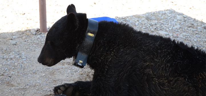
GPS collars are helping wildlife biologists understand how animals move and use the landscape. Biologists are able to capture wildlife and fit them with collars that collect GPS coordinates of their locations at preset times. Animals such as black bears can be monitored with collars, and their movements provide researchers with information on the animals’ use of habitats, activity patterns, home-range sizes, and prey use.

Various types of GPS collars collect and store location data in different ways. Store-on-board collars …

Novel Ground Truth Method for Crop Fields Combining a Global Positioning System (GPS) and a Handheld Geographic Information System (HGIS)


Introduction

For the state of Arizona, Geographic Information System (GIS) map templates are created on an annual basis depicting the location of all potential crop fields.  These templates, along with a Global Positioning System (GPS) and Handheld Geographic Information System (HGIS), can be used to efficiently create a database of what crops were present during field visits and to assess the accuracy of crop classifications derived from remote sensing data.  These products can be easily created from inside a vehicle …

What is the difference between a recreational grade GPS, a mapping grade GPS, and a survey grade GPS?

1. Recreational grade GPS receivers are sold at most box stores and at many sporting goods and camping stores. They are also available widely through Internet retailers. These units are the least expensive grade and are generally accurate to within +/- 25 feet (7.6 meters). These receivers run in the $100 to $600 range and are the type most often purchased by the general public.

2. Mapping grade GPS receivers are generally sold by “high end” and licensed resellers. These …

What is mobile GIS?

Mobile GIS is taking Geographic Information Systems (GIS) out of the office and into the field. A mobile GIS allows folks out in the field to capture, store, update, manipulate, analyze, and display geospatial data and information. Mobile GIS integrates one or more of the following technologies: * mobile devices (such as a PDA, tablet, or laptop computer, and in some countries mobile phones) * Geographic Information System (GIS) software * the Global Positioning System (GPS) * wireless communications for …

The Virginia 4-H Geocoin Adventure

The Virginia 4-H Geocoin Adventure

The Virginia 4-H Geocoin Adventure is the result of a collaborative effort between Virginia 4-H, the Virginia Geospatial Extension Program, and the National Geospatial Extension Network (NGTEN).

The Purpose of the Virginia 4-H Geocoin Adventure

To support geospatial and geographical awareness and encourage everyone to learn more about their communities and their world, and to faciliate the awareness of Science Technology Engineering and Math (STEM). As this initiative is an educational-based effort …

How to Geocache

You’ve decided to take the plunge and begin geocaching. Congratulations, you are ready for a fun adventure. This guide is designed to be used with Geocaching.com which is one of the larger social networking geocaching sites.

What you need:

  • GPS receiver
  • Internet connection (to get started)

IMPORTANT: If you have not used your GPS receiver, make sure to familiarize yourself with its operation prior to taking it out into the field. Make sure you take proper safety precautions and dress …

Geocaching: Retrieving / Grabbing a Trackable Item (Geocoin or Travelbug)

geocache.com page

If someone has mailed/given you a trackable item, or if you have found a trackable item, you will need to virtually “grab it” from its current holder (owner) before placing it in a different geocache.

We also have instructions for how to drop off a trackable item.

Log in to Geocaching.com

Navigate to “Trackable Items”


Trackable items can be searched by clicking the 'trackable item' option on the left side of the geocaching.com homepage


Enter the tracking code (stamped on the coin) into “Enter the Tracking Number of the Item:” or the enter the item name into “Search …

Safety in the Field – GPS Data Collection

Most people overlook simple safety considerations when doing field research and data collection. However, a few simple practices can make all the difference. Do not go into the field or send staff or researchers into the field without making sure they know some basic practices.

Anyone who has ever done field research knows that there are times when things go wrong in the field and there is potential for life-threatening or dangerous accidents to occur. A few simple safety considerations …

Geocaching: How to Drop Off a Trackable Item (Geocoin or Travelbug)

Geocaching often involves items in a cache that are considered trackable. These items have alpha-numeric codes that are located on the item. Most trackable items are called “travel bugs” or “geocoins” and have engraved numbers on their surface. If you have a trackable item or find one in a cache, the idea is to bring it to another cache and drop it off. That way, the item can move from location to location. As long as you log and report …

Learning Lesson – Understanding Accuracy and Precision with GPS (Garmin Map60cx)

General GPS Lesson – Exploring the Accuracy of Recreational Grade GPS Units

Instructional Information
GPS UNIT Level Menus/Pages
Garmin GPSmap 60cx Basic Find, Map, Compass

Summary: GPS accuracy and precision is always a topic of interest. This exercise is designed to demonstrate the level of accuracy and precision you can expect with recreational grade units.

Discussion: A general assumption with GPS units is that they can lead you to the exact location of a place, or that you can mark …