
We have a new website!
Please join us at https://mapasyst.org for the latest on the ways maps are being used for outreach and engagement in Cooperative Extension across the country.
…

…

|
Summary of skills covered: |
|
| Data needed: | Students will collect and graph their own data using a spectrometer. |
| Equipment and Software needed: |
Hardware: Spectrometer – a spectrometer kit is available from VirginiaView / the Virginia Geospatial Extension Program. Contact John McGee or Jim Campbell for details. Software: None |
| Related book exercise (if applicable): |
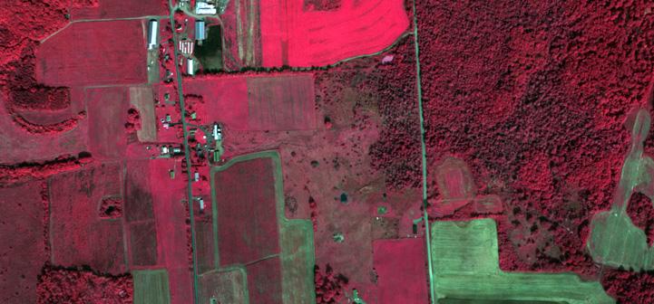
The goal of this lab is to learn about true and false color images. Using ArcMap, you will hone your skills at image interpretation and gain a better appreciation for the use of “invisible” radiation in remote sensing.
| Summary of skills covered: |
|
| Data needed: |
True Color and False Color Images (any image |
 Classified tree canopy layer in the Virginia Urban Tree Canopy Mapper – http://www.utcmapper.frec.vt.edu
Urban forests can be defined as the sum of all woody and associated vegetation in and around dense human settlements (Miller 1997). The people living in and around urban forests receive many direct and indirect benefits, such as the cooling effect of strategically placed trees around a house or the reduced costs of storm-water management (Konijnendijk et al. 2005). In order to estimate the social and ecosystem …
This term is often used when considering image acquisition through remote sensing and refers to the time of the year during which an image is taken. Leaf-on and leaf-off refer to the presence or lack of the foliage of woody species. Leaf-on imagery means that there is foliage on the tree or shrub species (or the species of interest). Leaf-off means that there is no foliage or a reduced amount of foliage on the tree or shrub species.
Sometimes it …
LIDAR (Light Detection and Ranging) is a remote sensing technology that uses a laser beam of light to measure the distance from a LIDAR sensor to distant objects. Its operation is similar to how SONAR measures distances underwater using sound pulses.
LIDAR often is used to measure the height of the ground’s surface and the height of features on the ground. In this case, a LIDAR sensor, mounted in a plane, is flown over the area to be imaged. The …
Classified tree canopy layer in the Virginia Urban Tree Canopy Mapper – http://www.utcmapper.frec.vt.edu
Two major categories of image classification techniques include unsupervised (calculated by software) and supervised (human-guided) classification.
Unsupervised classification is where the outcomes (groupings of pixels with common characteristics) are based on the software analysis of an image without the user providing sample classes. The computer uses techniques to determine which pixels are related and groups them into classes. The user can specify which algorism the software will …
A vegetation index (also called a vegetative index) is a single number that quantifies vegetation biomass and/or plant vigor for each pixel in a remote sensing image. The index is computed using several spectral bands that are sensitive to plant biomass and vigor. The most common vegetation index is the normalized difference vegetation index (NDVI). NDVI compares the reflectance values of the red and near-infrared regions of the electromagnetic spectrum using the following formula: NDVI=NIR-RED/NIR+RED NIR is the pixel’s reflectence …
Multispectral imagery is produced by sensors that measure reflected energy within several specific sections (also called bands) of the electromagnetic spectrum. Multispectral sensors usually have between 3 and 10 different band measurements in each pixel of the images they produce. Examples of bands in these sensors typically include visible green, visible red, near infrared, etc. Landsat, Quickbird, and Spot satellites are well-known satellite sensors that use multispectral sensors.
Hyperspectral sensors measure energy in narrower and more numerous bands than multispectral …
Factors to consider when selecting remote sensing products include spatial resolution, spectral resolution, radiometric resolution, and temporal resolution.
Spatial resolution refers to the size of the smallest object that can be detected in an image. The basic unit in an image is called a pixel. One-meter spatial resolution means each pixel image represents an area of one square meter. The smaller an area represented by one pixel, the higher the resolution of the image.
Spectral resolution refers to the number …