
We have a new website!
Please join us at https://mapasyst.org for the latest on the ways maps are being used for outreach and engagement in Cooperative Extension across the country.
…
…

A Geographic Information System (GIS) takes the information gathered from Global Positioning System (GPS) units and organizes the information into maps. GIS maps are interactive. They allow you to see the map from different angles, to zoom in and out, and to hide selected features. Some GIS programs are designed to help track storms or predict erosion patterns. Other systems, such as the GPS in a car, can provide a map and help you navigate to a particular location. …

Paula Kay Lazrus is an archaeologist and an associate professor in the Institute of Core Studies at St. John’s University and is also affiliated with the school’s Environmental Science Program. Paula teaches a basic environmental analysis class for the latter program and integrates various types of GIS tools into that class and others that she teaches. This also includes a multi-year academic service learning project with freshman that involves collecting GPS positions and basic measurements on the campus’ 3000 …
 Classified tree canopy layer in the Virginia Urban Tree Canopy Mapper – http://www.utcmapper.frec.vt.edu
Urban forests can be defined as the sum of all woody and associated vegetation in and around dense human settlements (Miller 1997). The people living in and around urban forests receive many direct and indirect benefits, such as the cooling effect of strategically placed trees around a house or the reduced costs of storm-water management (Konijnendijk et al. 2005). In order to estimate the social and ecosystem …

Quantum GIS (QGIS) provides much of the same functionality as Esri’s ArcGIS software (basic level) and has developed into a robust open-source alternative. The term open-source refers to the fact that the source code for the geographic information system (GIS) program is available to anyone, so people can try to improve and add to the software. The QGIS coding community has worked diligently to improve the program and add features in recent years.
There …
This story features one person’s five-year odyssey to bring the power of geospatial system technology to his small hometown in rural Iowa. It serves as an inspiration for other rural leaders who are intrigued by the possibilities of implementing geographic information systems (GIS) to serve their citizens.
In 1999 Bob Schultz, a training consultant for Iowa State University and the Iowa Department of Transportation, dreamed of putting the power of geographic information systems (GIS) to work in his rural hometown. …
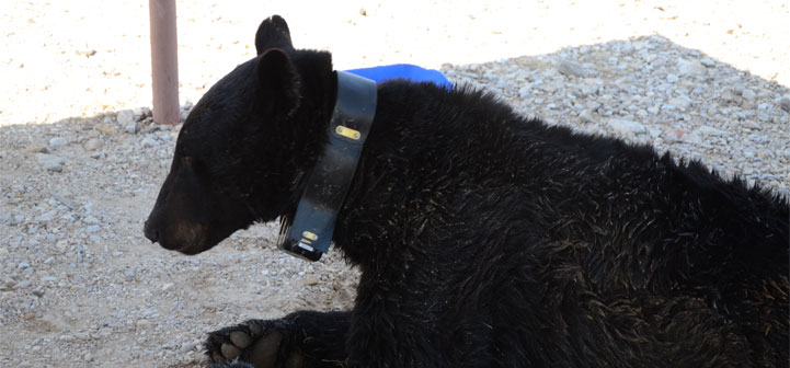
 GPS collars are helping wildlife biologists understand how animals move and use the landscape. Biologists are able to capture wildlife and fit them with collars that collect GPS coordinates of their locations at preset times. Animals such as black bears can be monitored with collars, and their movements provide researchers with information on the animals’ use of habitats, activity patterns, home-range sizes, and prey use.
Various types of GPS collars collect and store location data in different ways. Store-on-board collars …

ESRI has made two important changes to the ArcGIS Online platform: an account name change and a new account option.
You can use map packages to share map documents and associated data from ArcMap with other ArcMap users. A map package is created within ArcMap and contains the ArcMap document (.mxd) and all the data associated with that document.
Learn about other ESRI software formats you can use to share data.
To create the .mpk file:
1. Click File to display the drop-down menu, and then click …
You can use published map files to share map documents and associated data from ArcMap with ArcReader users. A published map file is created within ArcMap, using the Publisher extension, and contains the map and all of the associated data.
Learn about other ESRI software formats you can use to share data.
In ArcMap, you will need to activate the Publisher extension and then activate the …