Data Collection for Woody Vegetation

Collecting GPS Points in Woody Vegetation


Data collection for woody species presents difficulties because of canopy density and cover. The easiest position in which to take data is usually at the drip line of a species. However, that information is difficult to assign to a remotely sensed image because the majority of a pixel’s reflectance is commonly influenced by the density of the canopy at the point of the image acquisition. The canopy of species is thinner at the drip …

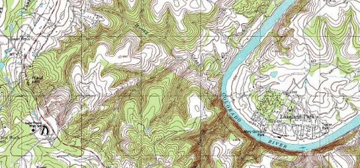
Topography and Understanding Topographic Maps

usgs topographic map


Among the many mapping tools available, the most commonly used is the topographic map. Topography is defined as the relief (relative elevations) of a surface and the relative relations between its natural and man-made features. Topographic maps systematically portray the spatial relationship among both the physical features, such as contour lines (lines of equal elevation) and hydrographic symbols, and cultural features, such as roads and administrative boundaries. Topographic maps are also known as “topo maps.”


Reading a topographic map begins …

Protecting cold water streams: GIS tackles thermal loading in urban watersheds

Stream in the woods
Stream in the woods

Cold-water streams are susceptible to a growing problem in rapidly urbanizing areas: thermal loading from heated water that runs off of streets, roofs, and parking lots. A new Dane County, Wisconsin, ordinance is aimed at managing thermal loading, along with other storm water and soil erosion concerns. Using geographic information systems (GIS) and other digital tools, Dane County landowners, developers, and conservationists can now identify land parcels that drain into vulnerable watersheds and predict thermal impacts

Building a Web-Based Forest Management Enterprise Information System with ESRI’s ArcGIS Server

By Mindia Brown, Virginia Department of Forestry

Local and state government entities are moving more of their products and applications to the Web to facilitate improved public access to information as well as to encourage more efficient data collection and analysis capabilities to support the day-to-day mandates of government entities. This article summarizes how the Virginia Department of Forestry is using ArcGIS server to support data collection from local foresters.

There are more than 15 million acres of forest land …

The Role of GIS in the National Gypsy Moth Slow the Spread Project (STS)

The gypsy moth is a serious invasive pest of hardwoods. A native of Europe and Asia, the insect was accidentally released in the United States more than 130 years ago near Boston, Massachusetts, and has now spread into the mid-Atlantic and midwestern states. Populations are cyclical, with periods of low abundance and periods of outbreaks. Since the first reported defoliation in Virginia in 1984, more than 5.3 million acres have been defoliated in the state, with treatment costs alone over …