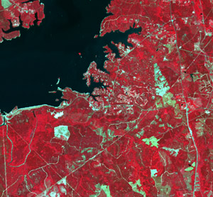
An orthophoto (also known as a orthophotograph) is an aerial image that has been geometrically corrected (ortho rectified) so that the image is uniform from edge to edge. Orthophotos are corrected to remove terrain effects (what happens when you take a 3-D surface and make it into a 2-D product) and distortions that result from the camera’s lens and the angle the photo was taken from the plane. The goal of ortho rectification is to create an image where distance …
What is the difference between land use and land cover?
Land use and land cover are classification systems that describe what is on the Earth’s surface at a given location. Often, land use and land cover are confused as interchangeable terms, but in actuality, they can describe very different characteristics of the landscape.
Land use describes activities, often associated with people, that take place on the land and represent the current use of property. Examples include multi-family residential homes, shopping centers, row crops, tree nurseries, state parks, reservoirs, etc.
Land …
How can I obtain an aerial or satellite image for my area?
Historic aerial photography (in some cases dating back to the 1930s) is often available from the Natural Resources Conservation Service (NRCS) regional/local office or the Farm Service Agency (FSA) office. Recently acquired aerial photography can often be obtained from your local government (city/county government) office. Contact the local government GIS coordinator. Most cities and larger towns have someone responsible for GIS. If not, then often the planning department, assessor’s office, or engineering department is a good place to get started.…
What is remote sensing, and how can it be used?
In the area of geospatial technologies, remote sensing generally refers to satellite imagery or aerial photography.
Remote sensing provides the ability to observe an object without coming in direct contact with that object. Your eyes are extremely sophisticated remote sensing devices!
The “bird’s eye” view from the satellite or airplane, in combination with its ability to store, analyze, and display the sensed data, make remote sensing a powerful tool. Remote sensing techniques generally fall into two categorizes: active remote sensing …
What is a spectral signature in remote sensing?
Features on the Earth reflect, absorb, transmit, and emit electromagnetic energy from the sun. Special digital sensors have been developed to measure all types of electromagnetic energy as it interacts with objects in all of the ways listed above. The ability of sensors to measure these interactions allows us to use remote sensing to measure features and changes on the Earth and in our atmosphere. A measurement of energy commonly used in remote sensing of the Earth is reflected energy …
Where can I find free aerial imagery?
Aerial imagery can be very useful in the classroom, public meetings, and land management planning and for general historical purposes. Aerial photography is one type of geospatial data that may require a large monetary investment. However, there are sources from which you may be able obtain aerial imagery for your area free of charge.
Most states have participated in national and statewide imagery programs since the middle 1990s (some have been involved even longer). Many of these states provide free …
RS Publications
Remote Sensing (RS) Publications
The following publications have content and articles specific to Remote Sensing.
- International Journal of Remote Sensing [ http://www.informaworld.com/smpp/title~content=t713722504] or [ http://www.rspsoc.org/publications/international-journal-of-remote-sensing-ijrs/]
- ISPRS Journal Of Photogrammetry And Remote Sensing (Formerly known as Remote Sensing Review) [ http://www.itc.nl/isprsjournal/] or also found online in ScienceDirect
- Geocarto International: A Multidisciplinary Journal of Remote Sensing and GIS (published until 1996) [ http://www.geocarto.com/geocarto.html]
- GIScience and Remote Sensing (formerly Mapping Sciences and Remote Sensing) [ http://www.ingentaconnect.com/content/bell/gis]
- Photogrammatric Engineering
Agricultural Remote Sensing Basics
Agricultural Remote Sensing Basics
John Nowatzki
Geospatial Technology Specialist NDSU Extension Service
Robert Andres
Professor UND Department of Space Studies
Karry Kyllo
Graduate Student UND Department of Space Studies
When farmers or ranchers observe their fields or pastures to assess their condition without physically touching them, it is a form of remote sensing. Observing the colors of leaves or the overall appearances of plants can determine the plant’s condition. Remotely sensed images taken from satellites and aircraft provide a means …
ASTER: Satellite Sensor

Description
A NASA EOS (Earth Observing System) satellite called Terra (EOS AM-1) carries the ASTER instrument. Terra launched on Dec. 18, 1999, …
LIDAR Derived Products

What Products Can be Generated from LIDAR?
LIDAR provides a cost-effective means to collect digital information about the Earth’s surface. Using LIDAR, we can obtain several “layers” of information from the landscape through a series of LIDAR returns. The first return of information to a LIDAR sensor would, for example, be associated with the highest features in the landscape (typically treetops, tops of buildings, etc.). Following data returns would be associated with understory vegetation below the initial tree or vegetation …
