Cotton Pickers


Cotton Pickers

Image:001.jpeg

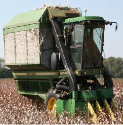
This is a two row cotton picker that
is harvesting cotton in Belle Mina, Al.
at the Tennessee Valley Research and Extension Center.

Image:002.jpeg

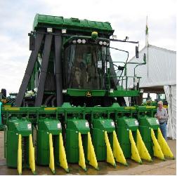
This is a six row cotton picker that
is on display at the 2007 Sunbelt Ag.
Expo. In Moultrie, Ga.

  • These John Deere cotton pickers are self-propelled machines
  • They remove cotton lint and seeds from the plant
  • Some of these machines can pick up to six rows of cotton at a time
  • There are two

Overview of Precision Agriculture

An Overview of Precision Agriculture

Prepared By: Dr. John Fulton and Daniel Mullenix, Auburn University

Image:Auto-Guided_Tractor.jpg

Highlights of Precision Agriculture[[1]]

Precision agriculture, also called “farming by the foot”, can be defined as a comprehensive system designed to optimize agricultural production through the application of crop information, advanced technology and management practices. A truly comprehensive approach to precision agriculture begins with crop planning and includes tillage, planting, chemical applications, harvesting, and post harvest processing of the crop. Basically precision agriculture is …

What is a TIGER file?

Definition
TIGER/Line files are a digital database of geographic features, such as roads, railroads, rivers, lakes, political boundaries, and census statistical boundaries, covering the entire United States. The Tiger database contains information about these features, such as their location in latitude and longitude, their names, the types of features, address ranges for most streets, the geographic relationship to other features, and other related information.

Features and Uses

The TIGER/Line files contain data describing three major types of features:

Line features …

Electromagnetic Spectrum

image description


Energy from sunlight is called the electromagnetic spectrum. Energy in the form of light waves travels from the sun to Earth. Light waves travel similarly to waves traveling across a lake. The distance from the peak of one wave to the peak of the next wave is the wavelength. Wavelengths are measured in micrometres (µm) or nanometers (nm). One µm is one-millionth of a meter or 1,000 nm. A nanometer is one-billionth of a meter. The visible region (light seen …

Data Collection for Woody Vegetation

Collecting GPS Points in Woody Vegetation


Data collection for woody species presents difficulties because of canopy density and cover. The easiest position in which to take data is usually at the drip line of a species. However, that information is difficult to assign to a remotely sensed image because the majority of a pixel’s reflectance is commonly influenced by the density of the canopy at the point of the image acquisition. The canopy of species is thinner at the drip …

Downloading GPS Data Using DNRGPS

John McGee, Virginia Tech


Note: several YouTube videos are also available to learn how to use DNRGPS


Overview

DNR Garmin was developed as an easy-to-use “point and click” software application that allows you to manage, manipulate, and save data from a Garmin GPS receiver for use in GIS programs such as ArcMap, MapWindow and AccuGlobe. DNR Garmin is shareware created and maintained by staff at the Minnesota Department of Natural Resources.  DNRGarmin works with ArcGIS 9.x, and was developed primarily …

DNRGPS Extension User Guide


DNRGPS, DNR Garmin, DNR GPS, GNSS

DNRGPS is an easy-to-use software application designed to manage, manipulate, and save GPS and GNSS information for use in GIS software programs and geospatial viewers (GoogleEarth, etc.). DNRGPS is commonly used to transfer waypoint and trackpoint data between GPS/GNSS units and computers. The GPS unit is connected to the computer with a cable.

DNRGPS is designed specifically for Garmin GPS receivers, but this software also works well with any other NMEA output GPS receiver (which includes most recreational grade GPS …

Topography and Understanding Topographic Maps

usgs topographic map


Among the many mapping tools available, the most commonly used is the topographic map. Topography is defined as the relief (relative elevations) of a surface and the relative relations between its natural and man-made features. Topographic maps systematically portray the spatial relationship among both the physical features, such as contour lines (lines of equal elevation) and hydrographic symbols, and cultural features, such as roads and administrative boundaries. Topographic maps are also known as “topo maps.”


Reading a topographic map begins …

Selecting Handheld GPS Units

photo credit: UConn CLEAR

Selecting Handheld GPS Units

AE-1269 (Revised), October 2007

John Nowatzki, Extension Geospatial Specialist

Christopher Daigle, Mechanical Engineering Student

Global Positioning System (GPS) units are available for a wide variety of prices. The information presented in this document focuses on several of the least expensive models from several suppliers. The types of units discussed are handheld, flash-card, Bluetooth, and secure digital units. The units are compared for several operational features. The following paragraphs describe the comparative features …

Agricultural Remote Sensing Basics

Agricultural Remote Sensing Basics

John Nowatzki
Geospatial Technology Specialist NDSU Extension Service

Robert Andres
Professor UND Department of Space Studies

Karry Kyllo
Graduate Student UND Department of Space Studies

When farmers or ranchers observe their fields or pastures to assess their condition without physically touching them, it is a form of remote sensing. Observing the colors of leaves or the overall appearances of plants can determine the plant’s condition. Remotely sensed images taken from satellites and aircraft provide a means …