Using Geospatial Tools to Assess Urban Tree Canopy

landcover viriginaClassified tree canopy layer in the Virginia Urban Tree Canopy Mapper – http://www.utcmapper.frec.vt.edu

Urban forests can be defined as the sum of all woody and associated vegetation in and around dense human settlements (Miller 1997). The people living in and around urban forests receive many direct and indirect benefits, such as the cooling effect of strategically placed trees around a house or the reduced costs of storm-water management (Konijnendijk et al. 2005). In order to estimate the social and ecosystem …

QGIS: Free and Open-Source GIS Software

qgis header logo

Quantum GIS (QGIS) provides much of the same functionality as Esri’s ArcGIS software (basic level) and has developed into a robust open-source alternative. The term open-source refers to the fact that the source code for the geographic information system (GIS) program is available to anyone, so people can try to improve and add to the software. The QGIS coding community has worked diligently to improve the program and add features in recent years.

How to Learn More about QGIS

There …

Perseverance Pays Off: How a Small Community in Iowa put GIS to Work

This story features one person’s five-year odyssey to bring the power of geospatial system technology to his small hometown in rural Iowa. It serves as an inspiration for other rural leaders who are intrigued by the possibilities of implementing geographic information systems (GIS) to serve their citizens.

In 1999 Bob Schultz, a training consultant for Iowa State University and the Iowa Department of Transportation, dreamed of putting the power of geographic information systems (GIS) to work in his rural hometown. …

Investigating Wildlife Movements with GPS Collars

black bear, GPS collar

wildlife, GPS collar, locations
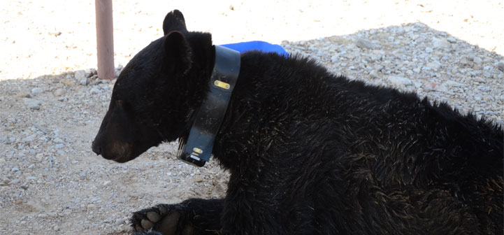
GPS collars are helping wildlife biologists understand how animals move and use the landscape. Biologists are able to capture wildlife and fit them with collars that collect GPS coordinates of their locations at preset times. Animals such as black bears can be monitored with collars, and their movements provide researchers with information on the animals’ use of habitats, activity patterns, home-range sizes, and prey use.

Various types of GPS collars collect and store location data in different ways. Store-on-board collars …

Ken Bates – Kentucky State University

Ken Bates

Ken Bates is the GeoSpatial Extension Specialist at Kentucky State University currently focusing on extending the reach of GIS to students, faculty, researchers and extension staff in the College of Agriculture, Food Science and Sustainable Systems.

He holds a B.S. in Agriculture from the University of Kentucky College of Agriculture (1997) and postgraduate study in soils and geology.

Prior to Kentucky State University, Ken Bates has worked as a GIS user, manager, and consultant for the last 30 years. He …

Nathan Mattox – City of Columbia Missouri

Nathan Mattox is the GIS Enterprise Systems Administrator for the City of Columbia Missouri.  Nathan focuses on extending and promoting the use of Geospatial Technologies throughout City Governmental units.  Nathan’s specializations include, GIS, GPS, GIS Enterprise Database Systems, local government aerial photo acquisition, online mapping systems, and Mobile GIS, all focused within the realm of local government systems.  Nathan is a founding member of Map@Syst.  He holds a B.S. and M.S. in Geography from Oklahoma State University.

Barron J. Orr – University of Arizona

Barron J. Orr is a Professor in the Office of Arid Lands Studies in the School of Natural Resources and the Environment at the University of Arizona where he has been on faculty since 2001. Termed “Geospatial Extension Specialist”, his position links the missions of NASA, USDA, NOAA, and that of Land Grant universities to bridge the gap between Earth systems science and technology and its use by the general public. His approach to knowledge transfer covers all facets of …

Frank Wideman

Frank_Wideman.JPG

Frank Wideman is a Natural Resources Engineering Specialist with the University of Missouri Extension.  He specializes in natural resource management, water quality, farm and home energy and emerging technologies.  He includes GIS, GPS, and Remote Sensing in all those areas.  He also utilizes distance education, social media, and community resource management to develop these programs.  He is currently serving as an eXtension Question Wrangler along with his duties for University of Missouri.  Frank has a B.S. & M.S. in …

John McGee – Virginia Tech

John McGee is an Associate Professor in the Department of Forest Resources and Environmental Conservation (FREC) at Virginia Tech.  At Virginia Tech, he heads up the Virginia Geospatial Extension Program and the VirginiaView consortium.  John’s programming focuses on supporting geospatial workforce development issues, including GIS, GPS, and Remote Sensing across Virginia (and beyond…).  John works with an array of partners across the Commonwealth, including:  Virginia Cooperative Extension, the Virginia Community College System faculty, the Virginia Space Grant Consortium, …

Leslie Pelch – Vermont Center for Geographic Information

picture of Leslie Pelch

Leslie has been the Outreach Coordinator at VCGI since 1997. She helps people understand geospatial technology, organizes professional development events, and offers hands-on GIS and GPS trainings. Leslie has a B.S. in Biology and a M.S. in Community Development and Applied Economics.

Currently, Leslie is working on projects that include coordinating the creation of a statewide parcel data layer in VT, a distributed conserved lands data update process, and a statewide GIS software license for K-12 educators in the state.…